Regions and municipalities in the Baltic states in 2015
HomeMapsRegions and municipalities in the Baltic states in 2015
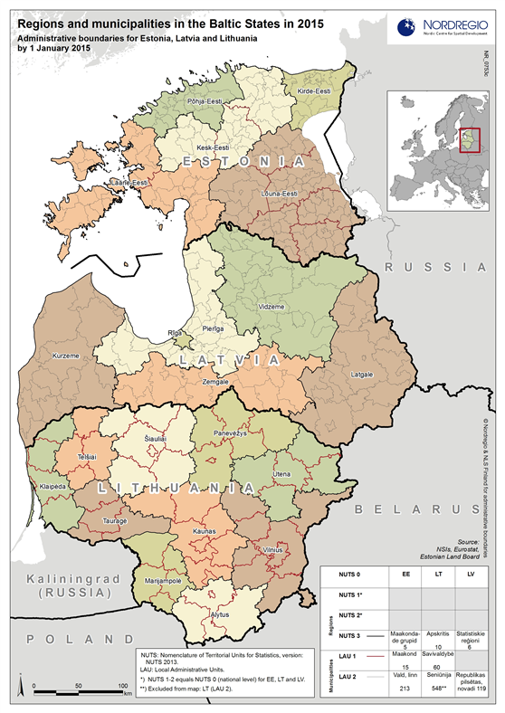
Administrative divisions according to NUTS and LAU nomenclature by 1 January 2015 for Estonia, Latvia and Lithuania
Map Facts
The map shows the regional and municipal divisions of the three Baltic states of Estonia, Latvia and Lithuania with the latest municipal boundaries (including merges) as of 1 January 2015. The regional divisions displayed in the map follow the individual countries national administrative system. However, they are presented in the map according to the all-European “NUTS” classification system, “Nomenclature of Territorial Units for Statistics”. Likewise, municipalities are presented in the map according to the European wide “LAU” system, “Local Administrative Units”.
The European standardized “NUTS” and “LAU” systems classify individual countries’ administrative levels into one common structure, e.g. by taking into consideration population size, and thus facilitate comparisons between European countries’ regions and municipalities. Such standardization is in many cases very useful from a statistical point of view, for example regarding analysing and presenting data on a comparable administrative level. However, these comparable administrative levels do not always match regarding policy relevance between different countries. E.g. in Estonia the LAU 1 level is the main regional division, with each county led by a governor, while the LAU 1 level in neighbouring Latvia was abolished as a consequence of Latvia’s administrative reform in 2009.
In addition, despite the standardization notable variations in the structure of the local administrative regions still exist, simply because of the varying number of NUTS and LAU units in different countries, and in relation to the countries’ sizes both in terms of population and area.
Map ID: 0753c
Designer/Cartographer
Linus Rispling
Data source
NSIs, Eurostat, Estonian Land Board
Published 24 February 2015
Terms of use
All images are the property of Nordregio. They may be freely used as long as the logo of Nordregio is clearly visible and the source is cited accordingly. Please give also the cartographer/designer/author credit and give full recognition to the data sources if named in the graphic.