HomeMapsReindeer Herding Area in the Nordic Countries
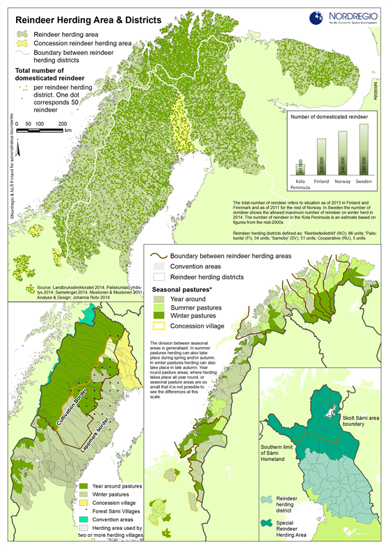
This map combines the overall Reindeer herding area – from the highlands of Oppland to the east coast of the Kola Peninsula and regional maps with national specifies
Map Facts
The Reindeer herding area – from the highlands of Oppland to the east coast of the Kola Peninsula covers a land area of over 500 000 km2. In each of the Nordic Countries this equates to approximately. 30-40% of the total land area, or 140 000 km2 in Norway, 160 000 km2 in Sweden and 123 000 km2 in Finland. In the Kola Peninsula the reindeer herding area is approximately 83 000 km2.
Reindeer herding is seen as central to Sámi livelihoods and is viewed as a fundamental part of Sámi culture – even though only some 10-15% of the Sámi people are now actually involved in such practices. In some parts of the Nordic countries, only people designated as Sámi can practice reindeer herding.
The national maps from Finland, Norway and Sweden show the national specific issues in relation to different parts on the reindeer herding area and to seasonal pattern.
All images are the property of Nordregio. They may be freely used as long as the logo of Nordregio is clearly visible and the source is cited accordingly. Please give also the cartographer/designer/author credit and give full recognition to the data sources if named in the graphic.
