Cruise ship tourism in the West Nordic countries in 2014
HomeMapsCruise ship tourism in the West Nordic countries in 2014
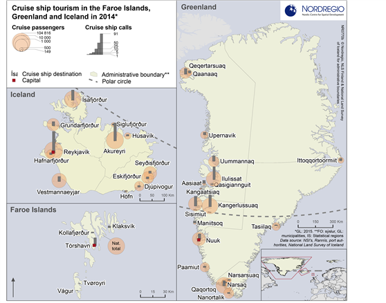
Number of cruise ship passengers and cruise ship calls
Map Facts
This map shows international cruise ship passengers and calls in the West Nordic countries not including regular, scheduled ferry connections in 2014 (2015 for Greenland as no earlier data is available). The circles indicate the number of cruise passengers and the grey bars represent the number of cruise ship calls in each port.
Iceland received a significant number of cruise ships all around its coast, with Reykjavík, Akureyri, and Ísafjarðarbær the busiest ports in 2014. In Faroe Islands, Torshavn is the primary cruise ship destination. Greenland had cruise ship arrivals at almost 20 ports in 2015. Consistent with the settlement structure in Greenland, most cruise calls to Greenland are found in the West Coast.
Data source
NSI’s, Rannís (IS), port authorities, National Land Survey of Iceland
Published 15 December 2016
Terms of use
All images are the property of Nordregio. They may be freely used as long as the logo of Nordregio is clearly visible and the source is cited accordingly. Please give also the cartographer/designer/author credit and give full recognition to the data sources if named in the graphic.