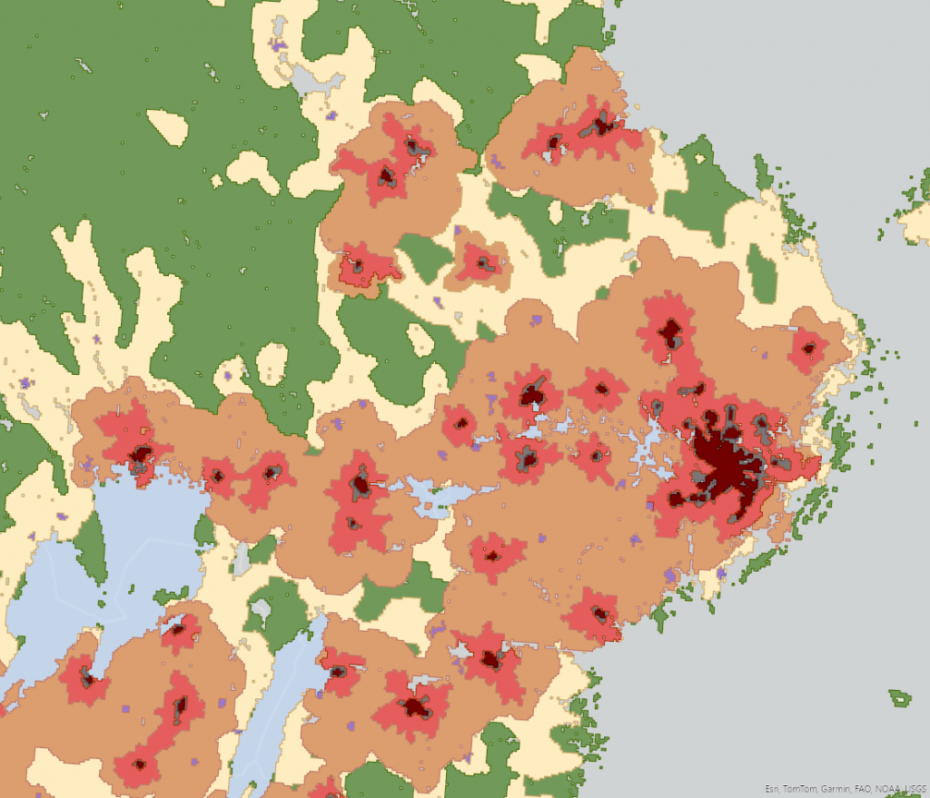
Uppsala, Sweden’s largest rural municipality – while being Sweden’s fourth largest city? Up until now, it was impossible to conduct a comparative Nordic analysis of such internal differences within municipalities. But with Nordregio’s new tool, you can move beyond the traditional municipal-level analysis using a 1×1 km grid, allowing for an unprecedented level of detail in territorial studies.
The Nordic urban-rural typology illustrates the complexity and diversity within the regions and captures nuances that have previously been missed. Mats Stjernberg, senior researcher at Nordregio explains:
“In reality, a municipality can simultaneously comprise various types of areas. If we classify a municipality like Uppsala as being either ‘a’ or ‘b’, we lose the ability to perceive these differences within the municipality.”
“The most novel aspect is that it is based on a grid level, down to kilometre level. Until now, there hasn’t been anything as detailed at a Nordic level.”, Anna Vasilevskaya, GIS Analyst at Nordregio.
The typology can be used to get insights into demographic trends and significant advancement in spatial analysis, for a more sophisticated approach to addressing and planning for the needs of diverse territories, for example planning of housing markets, and urban and rural services.
Up until now, the most used classification system for international comparisons between countries has been DEGURBA from Eurostat, classifying areas into three types of territories: cities (densely populated areas); towns and suburbs (intermediate density areas) and rural areas (thinly populated areas). This set-up of parameters can create classifications that don’t always correspond to what those municipalities are like in reality. For example, Gällivare in northern Sweden, is classified as an intermediate municipality by DEGURBA. Meaning, not urban, not rural, but somewhere in between. Gällivare is, however, extremely sparsely populated and even uninhabited in large parts, with most of the population living very concentrated in that locality, making the classification of “intermediate” not really appropriate. Using the Nordic urban-rural typology – we can create a more detailed analysis than ever, discovering that approximately 87 percent of the land area in Gällivare is made up of sparsely populated rural areas, while 68 percent of the population lives quite concentrated in local centres in rural areas.
The typology and a new report “Towards a grid-based Nordic territorial typology – a new tool for analysis across the urban-rural continuum” presents an analysis of settlement patterns and population changes using this typology. Both were launched at an event on 19 March 2024. The report reveals that, based on land classification, the Nordic countries are primarily rural. But settlement patterns are uneven, with a significant portion of the population residing in urban centers. Over the last few decades, there has been a steady trend towards urbanization, and a growth in areas close to cities, so called peri-urban regions.
“This is primarily an analytical tool, not created with political purposes that some typologies are developed for. However, because it enables a deeper understanding of the urban-rural continuum, it supports planning and decision-making at a national level, and possibly within regions and municipalities”, Stjernberg explains.
The data in the typology is mostly based on open-source data, and the GIS layers can be downloaded to be combined with the organisations’ own data for personalised and organisation specific analysis.
Looking to the future, Mats Stjernberg spots a possibility to combine the urban-rural typology with Nordregio’s Nordic Service Mapper tool. This integration could offer even more detailed insights for Nordic planners, enabling them to make well-informed decisions based on comprehensive data about demographic trends, service accessibility, and other critical factors affecting the region’s development. As the Nordic urban-rural typology is introduced to the public and the research community, it opens up new possibilities for understanding and shaping the diverse landscapes of the Nordic countries, providing a foundation for targeted, effective planning and policy-making.
Watch the recorded launch of the typology and new report, for insights from the researchers first-hand.