Living in a remote area often causes challenges for accessing the necessary services. However, with the increasing digitalisation and innovative solutions, there are many opportunities to create a more inclusive environment. On this page, you can learn about our latest projects and results related to the accessibility studies.
Welcome to the Nordic Service Mapper! This interactive mapping tool visualises the proximity to different types of services, including grocery stores, pharmacies, libraries and schools, across the Nordic Region. Try it out! This mapping tool was produced by Nordregio through the funding from the Nordic Thematic Group on Sustainable Rural Development 2017-2020. Visit Nordic Service Mapper in a full window for better user experience: www.nordicservicemapper.org
Publications on Accessibility Topic
Health care and social care are not only important aspects of the Nordic welfare state model. The development of those sectors also has an important impact on the regional development and sustainability (economically, socially and environmentally) in the Nordic Region. The use of digital solutions in both sectors is increasing across all the Nordic countries. However, in relation to the ambitious goals set out in national digitalisation and eHealth strategies, digitalisation in health care and social care can be seen to have been developing at a relatively moderate pace.
This accessibility study is an annex to the main VOPD main report and shows the current situation regarding the potential geographic accessibility of health care for the residents in the VOPD case study regions. The report also addresses the situation regarding the potential accessibility of social care for the elderly population in the VOPD case study municipalities.
This policy brief examines how small and medium-sized (SMS) cities can benefit from the introduction of a high-speed train connection. Our results indicate that such transport infrastructure projects might not be the best fit for all SMS cities, even though they can contribute to local urban developments, especially in medium-sized cities.
This report shows that a reliable transport link has been central to maintaining and developing cross-border relations in the Kvarken region. Sea traffic has been the lifeline enabling cross-border interactions and exchanges throughout the centuries, and cross-border cooperation has remained largely dependent on the ferry connection until this day.
Cross-border cooperation has long been a strong element of the Nordic Region’s efforts to become better integrated, while simultaneously working towards shared ambitions in the areas of economic, environmental and social sustainability.
Health care and care with distance-spanning technologies, e-health and digitalisation (VOPD)
The project aims at supporting the development of distance spanning digital solutions in health care and care in the Nordic Region. It was initiated by the Swedish chairmanship program of the Nordic Council of Ministers 2018 and runs until 2020. The objective is to survey the use of digital technology in health care to display best practice and analyse regional development effects. The project has published 24 distance-spanning solutions for healthcare and social care.
The following categories of distance solutions in health care and care are analysed: remote treatment, remote monitoring, remote meetings, new digital services for healthcare and social care. This category involves finding new innovative solutions.
Find out more about the project here.
Maps of In-depth accessibility study
The map illustrates the accessibility of primary care in Nordjylland in Denmark. The colours represent car ride times in minutes from the place of residency to the nearest health care facility within a certain service type, with a travel range of 10 minutes to two hours. The health care facilities are also located on the map.
The map illustrates the accessibility of out-patient drop-in care during office hours in Nordjylland in Denmark. The colours represent car ride times in minutes from the place of residency to the nearest health care facility within a certain service type, with a travel range of 10 minutes to two hours. The health care facilities are also located on the map.
See the better resolution map here.
The map illustrates the accessibility of out-patient drop-in care during non-office hours in Nordjylland in Denmark. The colours represent car ride times in minutes from the place of residency to the nearest health care facility within a certain service type, with a travel range of 10 minutes to two hours. The health care facilities are also located on the map.
See the better resolution map here.
The map illustrates the accessibility of in-patient care in Nordjylland in Denmark. The colours represent car ride times in minutes from the place of residency to the nearest health care facility within a certain service type, with a travel range of 10 minutes to two hours. The health care facilities are also located on the map.
See the better resolution map here.
The map illustrates the accessibility of highly specialised care in Nordjylland in Denmark. The colours represent car ride times in minutes from the place of residency to the nearest health care facility within a certain service type, with a travel range of 10 minutes to two hours. The health care facilities are also located on the map.
See the better resolution map here.
The map illustrates the accessibility of primary care during office hours in South Karelia in Finland. The colours represent car ride times in minutes from the place of residency to the nearest health care facility within a certain service type, with a travel range of 10 minutes to two hours. The health care facilities are also located on the map.
See the better resolution map here.
The map illustrates the accessibility of out-patient drop-in care during office hours in South Karelia in Finland. The colours represent car ride times in minutes from the place of residency to the nearest health care facility within a certain service type, with a travel range of 10 minutes to two hours. The health care facilities are also located on the map.
See the better resolution map here.
The map illustrates the accessibility of out-patient drop-in care during non-office hours and in-patient care in South Karelia in Finland. The colours represent car ride times in minutes from the place of residency to the nearest health care facility within a certain service type, with a travel range of 10 minutes to two hours. The health care facilities are also located on the map.
See the better resolution map here.
The map illustrates the accessibility of primary care in Västerbotten in Sweden. The colours represent car ride times in minutes from the place of residency to the nearest health care facility within a certain service type, with a travel range of 10 minutes to two hours. The health care facilities are also located on the map.
See the better resolution map here.
The map illustrates the accessibility of out-patient drop-in care in Västerbotten in Sweden. The colours represent car ride times in minutes from the place of residency to the nearest health care facility within a certain service type, with a travel range of 10 minutes to two hours. The health care facilities are also located on the map.
See the better resolution map here.
The map illustrates the accessibility of in-patient care in Västerbotten in Sweden. The colours represent car ride times in minutes from the place of residency to the nearest health care facility within a certain service type, with a travel range of 10 minutes to two hours. The health care facilities are also located on the map.
See the better resolution map here.
The map illustrates the accessibility of highly specialised care in Västerbotten in Sweden. The colours represent car ride times in minutes from the place of residency to the nearest health care facility within a certain service type, with a travel range of 10 minutes to two hours. The health care facilities are also located on the map.
See the better resolution map here.
To secure better access to general practitioners for the rural population, the region of Västerbotten has developed the concept of virtual health
rooms (VHRs). These VHRs are unstaffed, which means that they have no regular health personnel in situ. They are equipped with distance-spanning technology, which means that patients can go there to take consultations from a practitioner online, conducting health checks such as measuring blood pressure or heart rate.
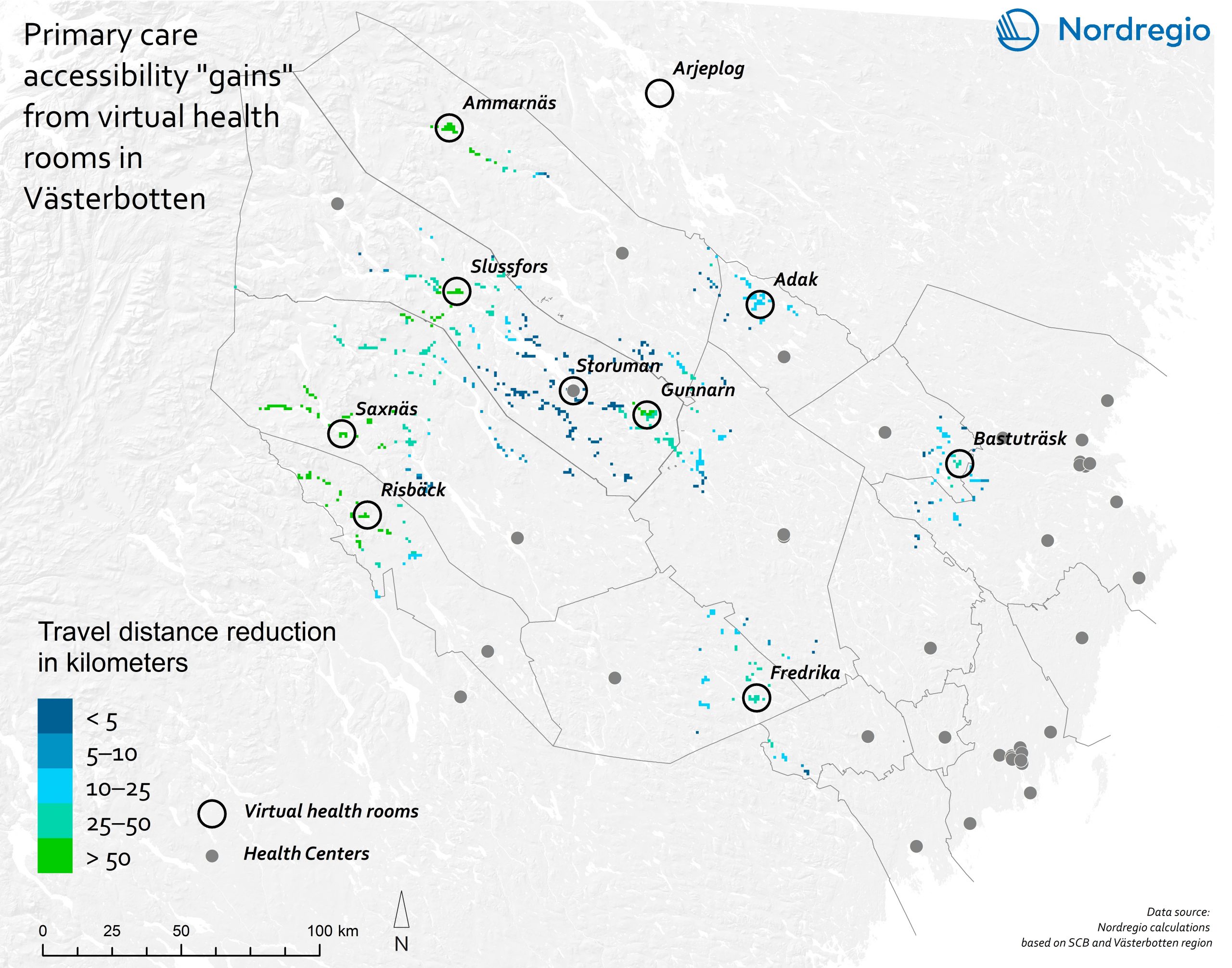
See the better resolution map here.
The map illustrates the accessibility of primary care in Sogn og Fjordane in Norway. The colours represent car ride times in minutes from the place of residency to the nearest health care facility within a certain service type, with a travel range of 10 minutes to two hours. The health care facilities are also located on the map.
See the better resolution map here.
The map illustrates the accessibility of out-patient drop-in care during office hours in Sogn og Fjordane in Norway. The colours represent car ride times in minutes from the place of residency to the nearest health care facility within a certain service type, with a travel range of 10 minutes to two hours. The health care facilities are also located on the map.
See the better resolution map here.
The map illustrates the accessibility of out-patient drop-in care during non-office hours in Sogn og Fjordane in Norway. The colours represent car ride times in minutes from the place of residency to the nearest health care facility within a certain service type, with a travel range of 10 minutes to two hours. The health care facilities are also located on the map.
See the better resolution map here.
The map illustrates the accessibility of in-patient care in Sogn og Fjordane in Norway. The colours represent car ride times in minutes from the place of residency to the nearest health care facility within a certain service type, with a travel range of 10 minutes to two hours. The health care facilities are also located on the map.
See the better resolution map here.
The map illustrates the accessibility of primary care in Eastern health region in Iceland. The colours represent car ride times in minutes from the place of residency to the nearest health care facility within a certain service type, with a travel range of 10 minutes to two hours. The health care facilities are also located on the map.
See the better resolution map here.
The map illustrates the accessibility of out-patient drop-in care in Eastern health region in Iceland. The colours represent car ride times in minutes from the place of residency to the nearest health care facility within a certain service type, with a travel range of 10 minutes to two hours. The health care facilities are also located on the map.
See the better resolution map here.
The map illustrates the accessibility of in-patient care in Eastern health region in Iceland. The colours represent car ride times in minutes from the place of residency to the nearest health care facility within a certain service type, with a travel range of 10 minutes to two hours. The health care facilities are also located on the map.
See the better resolution map here.
Maximised Mobility and Accessibility of Services in Regions Affected by Demographic Change (MAMBA)
The project aims to promote sustainable “people-to-service” and “service-to-people” mobility solutions in rural areas, and involve users in the innovation process and improve both dimensions of mobility through a number of activities.
The MAMBA consortium evaluated existing, sustainable ways of managing and financing rural mobility that could be transferred to other regions. New mobility solutions, such as rural car sharing, transport on demand (ToD), ride sharing applications, and mobility as a service (MaaS) have also been initiated by the MCs as pilot actions.
Find out more on MAMBA website here: www.mambaproject.eu
Transport for Regional Integration in Border Regions (TRIBORDER)
The project aims to analyze the potential challenges of planning and developing transport connections across the borders in the Nordic region. The activities which contributes to the work of the Nordic Thematic Group for Sustainable Cities and Urban Development, 2017-2020. are: investigate the local reception of the fast rail connection between Oslo and Stockholm; analyze effects of the ferry connection between Umeå and Vaasa on their surrounding urban regions; focus on the public transport system in the cross-border region of Greater Copenhagen. It analyzes connectivity and urban planning in relation to public transport.
Find out more about the project here.
Maps of Transport for Regional Integration in Border Regions project
Greater Copenhagen Region
This map shows the Greater Copenhagen Region, which constists of 85 municipalities and four regional authorities: the Capital Region of Denmark and Region Zealand on the Danish side, and the regions of Skåne and Halland on the Swedish side.
Travel time by train from Copenhagen or Malmö
The travel times indicate the fastest morning connection outbound from Copenhagen Central Station or Malmö Central Station, departing after 6:30AMand arriving before 9:00AM. The station catchments are calculated by bicycle travel time for any time remaining beyond train travel. For instance, a 35-minute train ride and a 10-minute cycle ride results in a 45-minute total travel time. The shades of green indicate the travel time to other train stations and their surrounding areas in four main classes: up to 15 minutes, 16 to 30 minutes, 31 to 45 minutes and 46 to 60 minutes. The areas not highlighted in green on the map are further than one hour by train from either Copenhagen or Malmö main train stations.
Nordic cross-border infrastructure projects
The cross-border infrastructure projects shown on the map are designed to show the importance of further development of movements and infrastructure plans across Nordic national borders, in opposition to infrastructure projects which are drawn up primarily within a national context, without a specific focus on cross-border linkages. As can be seen on the map, the Nordic cross-border committees have identified a number of planned or envisaged cross-border infrastructure projects which are considered important for the development of cross-border transport in the Nordic region.
Accessibility to Health Services in Iceland
This pilot study aims to objectively and quantitatively measure the accessibility of all Icelandic residents to health services, which are distinguished between (for instance) regional hospitals, clinics, Doctor’s offices and other medical facilities.
The results are visualised in a short working paper with a series of maps and quantitative results profiled in tables and charts. A brief overview and analytical text is also provided, including a feasibility analysis for a continued study covering all of the aforementioned sectors.
Find out more about the project here.
Maps of Accessibility to Health Services in Iceland project
Accessibility to specialised hospitals in Iceland
The map shows the accessibility to specialised hospitals in Iceland. Highly specialised care, being the most professional form of health care service, is also the most restricted in terms of accessibility for the general population in Iceland, compared to other types of health care. The two hospitals offering specialised care are located in Reykjavik and Akureyri. More than two-thirds of the inhabitants (70.85%) can access specialised health care services within a 30-minute car ride, and a car ride of one hour covers 85.39% of the Icelandic population who need such a service.
Accessibility to specialised hospitals and hospitals with 24/7 surgical services in Iceland
The map shows the accessibility to both specialised hospitals and hospitals with 24/7 surgical services in Iceland. Apart from the two hospitals providing specialised care, three more health care facilities providing 24/7 surgical services in the country. Nearly 80% of the inhabitants (76.2%) can access such health care services within a 30-minute car ride, and a car ride of one hour covers 89.4% of the Icelandic population who need such a service.
Accessibility to specialised hospitals, hospitals with 24/7 surgical services and hospitals with overnight care
The map shows the accessibility to specialised hospitals, hospitals with 24/7 surgical services and hospitals with overnight care in Iceland. Overnight care is available in six more healthcare facilities in the country. Over 90% of the national population (91.2%) are able to access these services within a 30-minute car ride, while a one-hour car ride covers 96.2% of the national population.
Accessibility to specialised hospitals, hospitals with 24/7 surgical services, hospitals with overnight care and primary health care centres
The map shows the accessibility to specialised hospitals, hospitals with 24/7 surgical services, hospitals with overnight care and primary health care centres in Iceland. The people in Iceland have widespread access to primary health care, thanks to the 47 health care facilities in the country which provide such a service. These four types of health care service cover 98.8% of the national population within a 30-minute car ride, and 99.9% of the population is covered by a one-hour car ride.
Accessibility to specialised hospitals, hospitals with 24/7 surgical services, hospitals with overnight care, primary health care centres and part time health care centres
The map shows the accessibility to specialised hospitals, hospitals with 24/7 surgical services, hospitals with overnight care, primary health care centres and part time health care centres in Iceland. In total, 47 health care facilities provide primary health care and 22 health care facilities provide part time primary health care in the country, contributing to an established pattern of extensive accessibility across Iceland. Altogether, all the health care facilities cover 99.5% of the population within a 30-minute ride, and a one-hour ride covers nearly the entire Icelandic population (99.95%).