80 Maps
New urban-rural typology of Nordic countries
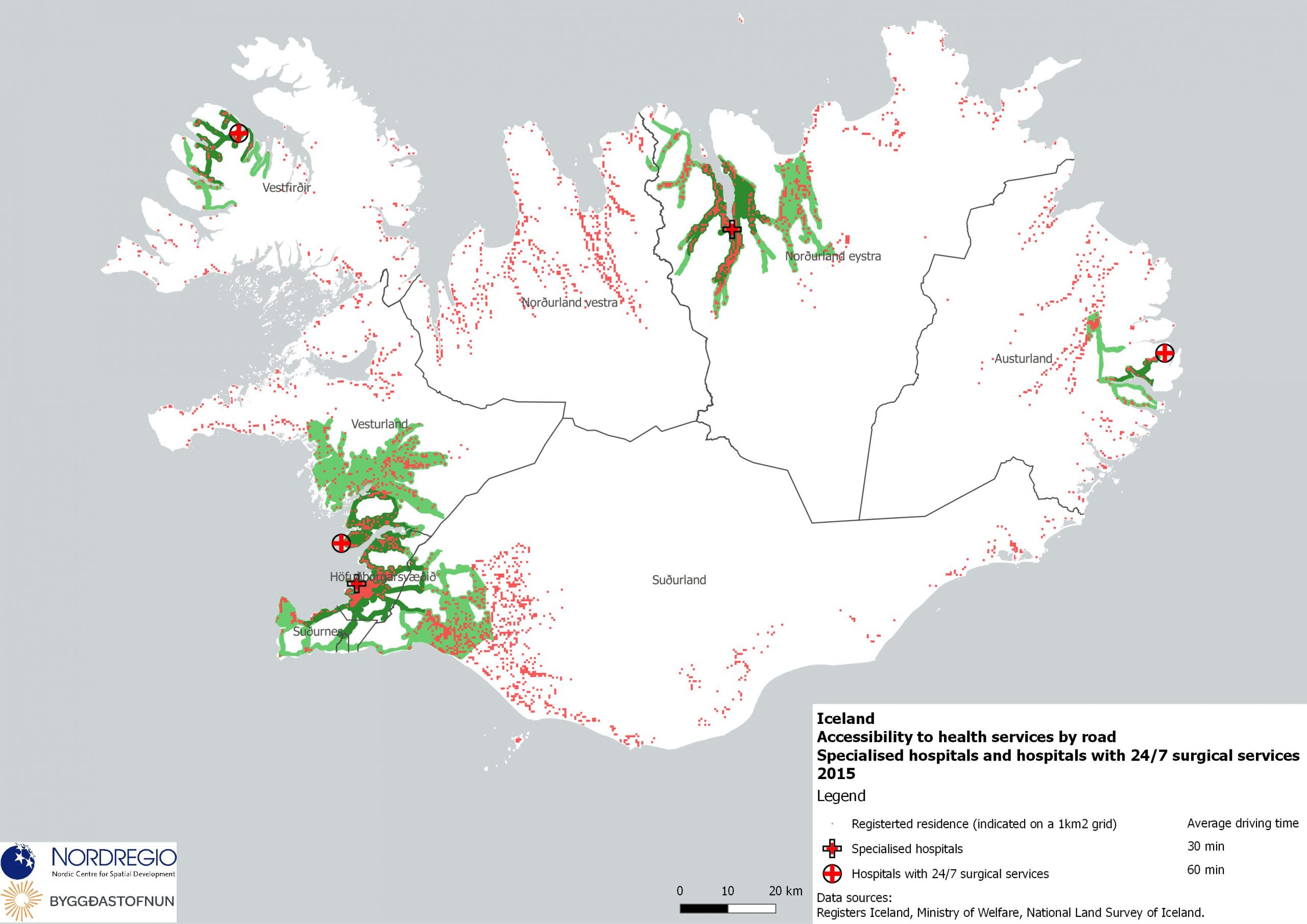
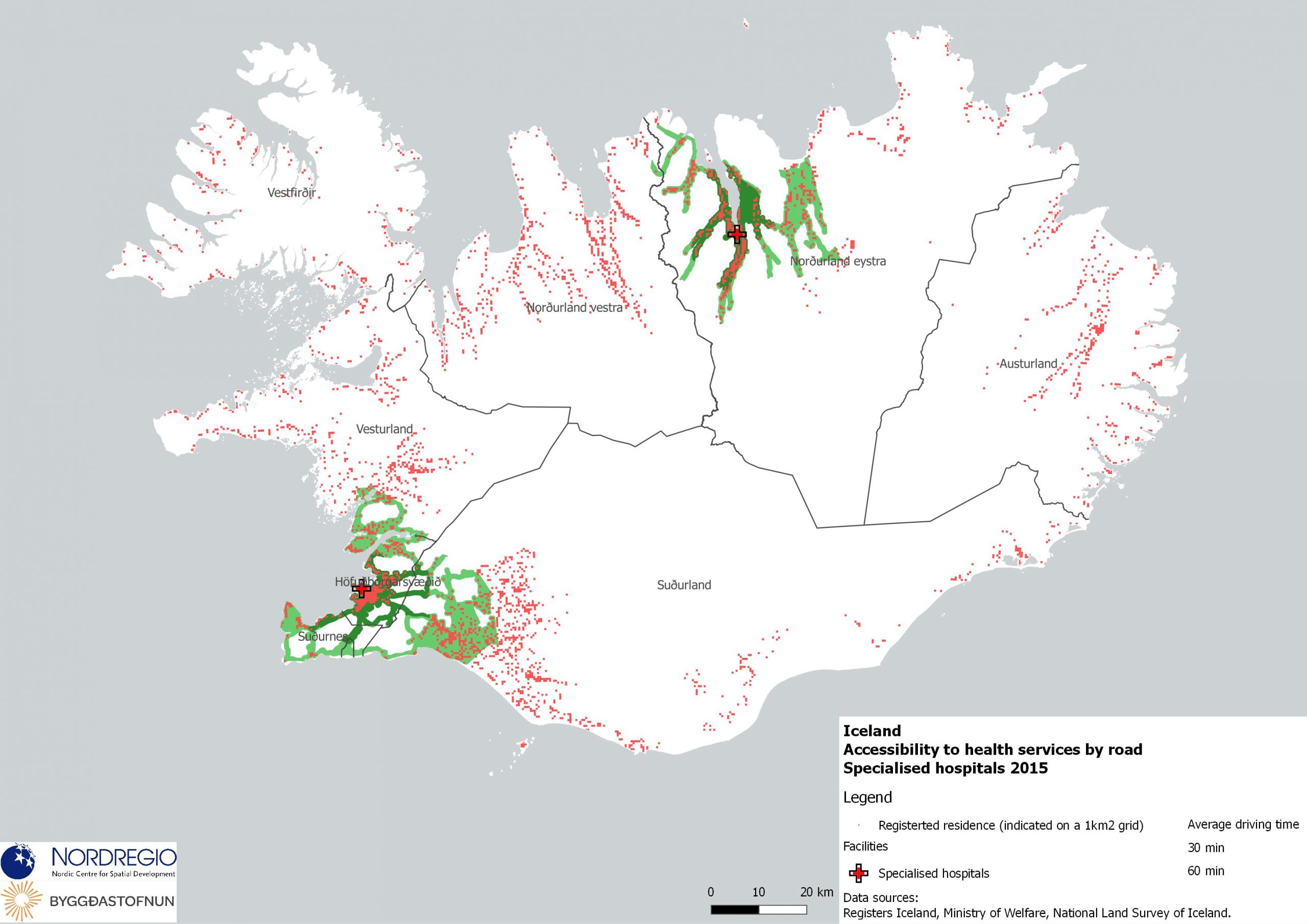
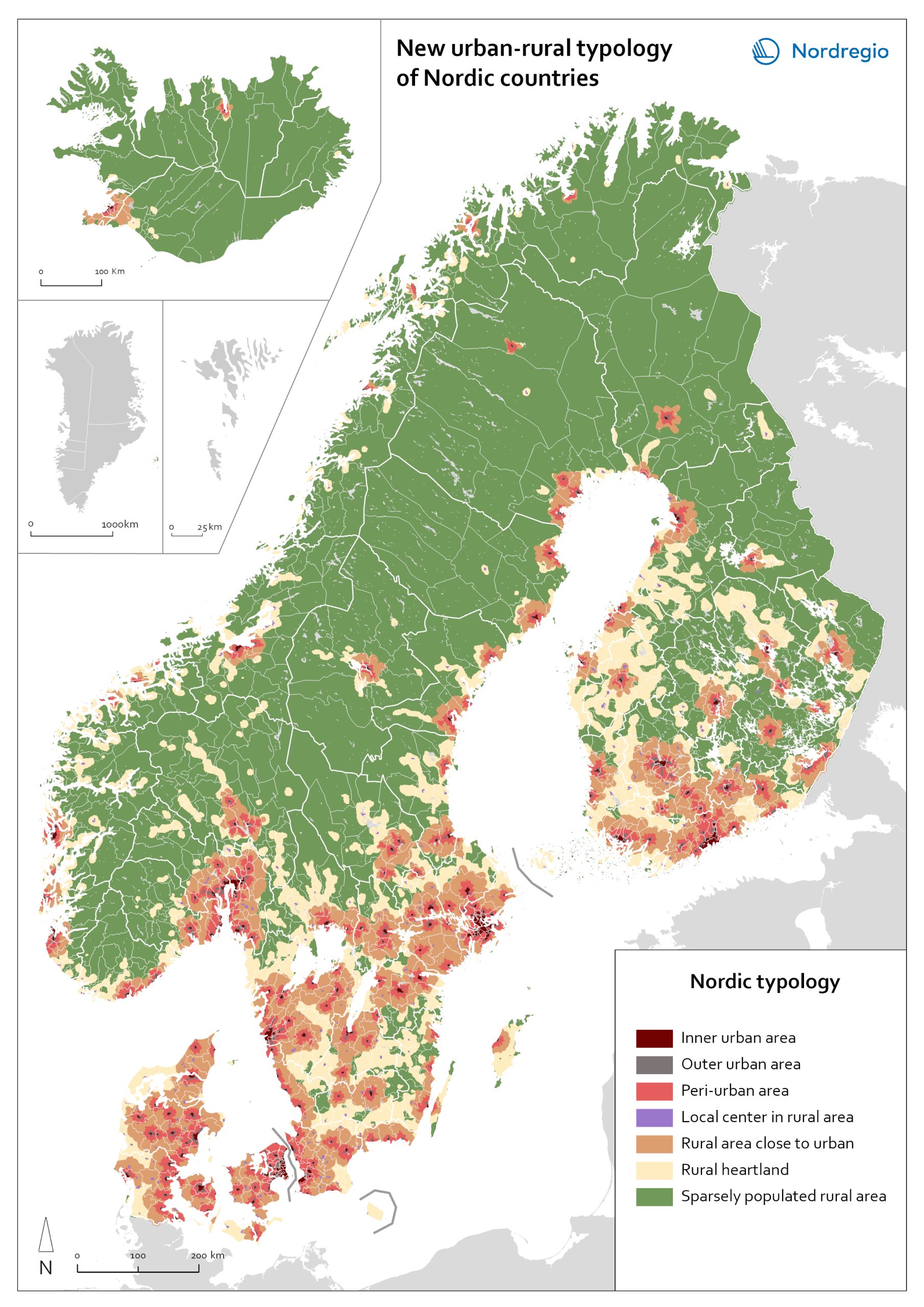
A map portrays a new urban-rural typology based on the grid-level data. New Nordic urban-rural typology is a grid-based classification of areas developed by the Nordic Thematic groups 2021-2024 to enable more accurate cross-Nordic statistical comparisons. The seven classes are defined based on population density, proximity measures and land cover parameters. Read more about the typology here . Inner urban area is the most densely populated part of the urban core. Urban cores are clustered cells summing up to at least 15 000 inhabitants, and these are divided into Inner and Outer urban areas based on density criterion (population density and building floor space). Outer urban area is the least densely populated part of the urban core. Urban core areas are clustered cells with at least 15 000 inhabitants, and these are divided into Inner and Outer urban areas based on density criterions (population density and building floorspace). Peri-urban area is the intermediate zone between urban core and the rural. It is based on generalized travel-time estimates from the edges of outer urban areas (6 min travel-time zones) and smaller urban settlement (4,5 min travel-time zones). Local centers in rural areas are population centers located outside urban areas, small towns and large parish villages where population is between 5000-14999 inhabitants. Rural areas close to urban areas have a rural character that are functionally connected and close to urban areas. In average this means 20-30 of minutes’ drive time from the edge of outer urban area. This class overwrites the area classes ‘Rural heartland’ and ‘Sparsely populated rural areas’. Rural heartland. Rural areas with intensive land use, with a relatively dense population and a diverse economic structure at the local level. Most of the agricultural land is in this class. Sparsely populated rural areas. Sparsely populated areas with dispersed small settlements that are located at a distance from each other.…
 2023 January
 - Administrative and functional divisions
- Nordic Region
New urban-rural typology of Nordic countries
A map portrays a new urban-rural typology based on the grid-level data. New Nordic urban-rural typology is a grid-based classification of areas developed by the Nordic Thematic groups 2021-2024 to enable more accurate cross-Nordic statistical comparisons. The seven classes are defined based on population density, proximity measures and land cover parameters. Read more about the typology here . Inner urban area is the most densely populated part of the urban core. Urban cores are clustered cells summing up to at least 15 000 inhabitants, and these are divided into Inner and Outer urban areas based on density criterion (population density and building floor space). Outer urban area is the least densely populated part of the urban core. Urban core areas are clustered cells with at least 15 000 inhabitants, and these are divided into Inner and Outer urban areas based on density criterions (population density and building floorspace). Peri-urban area is the intermediate zone between urban core and the rural. It is based on generalized travel-time estimates from the edges of outer urban areas (6 min travel-time zones) and smaller urban settlement (4,5 min travel-time zones). Local centers in rural areas are population centers located outside urban areas, small towns and large parish villages where population is between 5000-14999 inhabitants. Rural areas close to urban areas have a rural character that are functionally connected and close to urban areas. In average this means 20-30 of minutes’ drive time from the edge of outer urban area. This class overwrites the area classes ‘Rural heartland’ and ‘Sparsely populated rural areas’. Rural heartland. Rural areas with intensive land use, with a relatively dense population and a diverse economic structure at the local level. Most of the agricultural land is in this class. Sparsely populated rural areas. Sparsely populated areas with dispersed small settlements that are located at a distance from each other.…
- 2023 January
- Administrative and functional divisions
- Nordic Region