19 Maps


Smart specialisation domains in Swedish regions
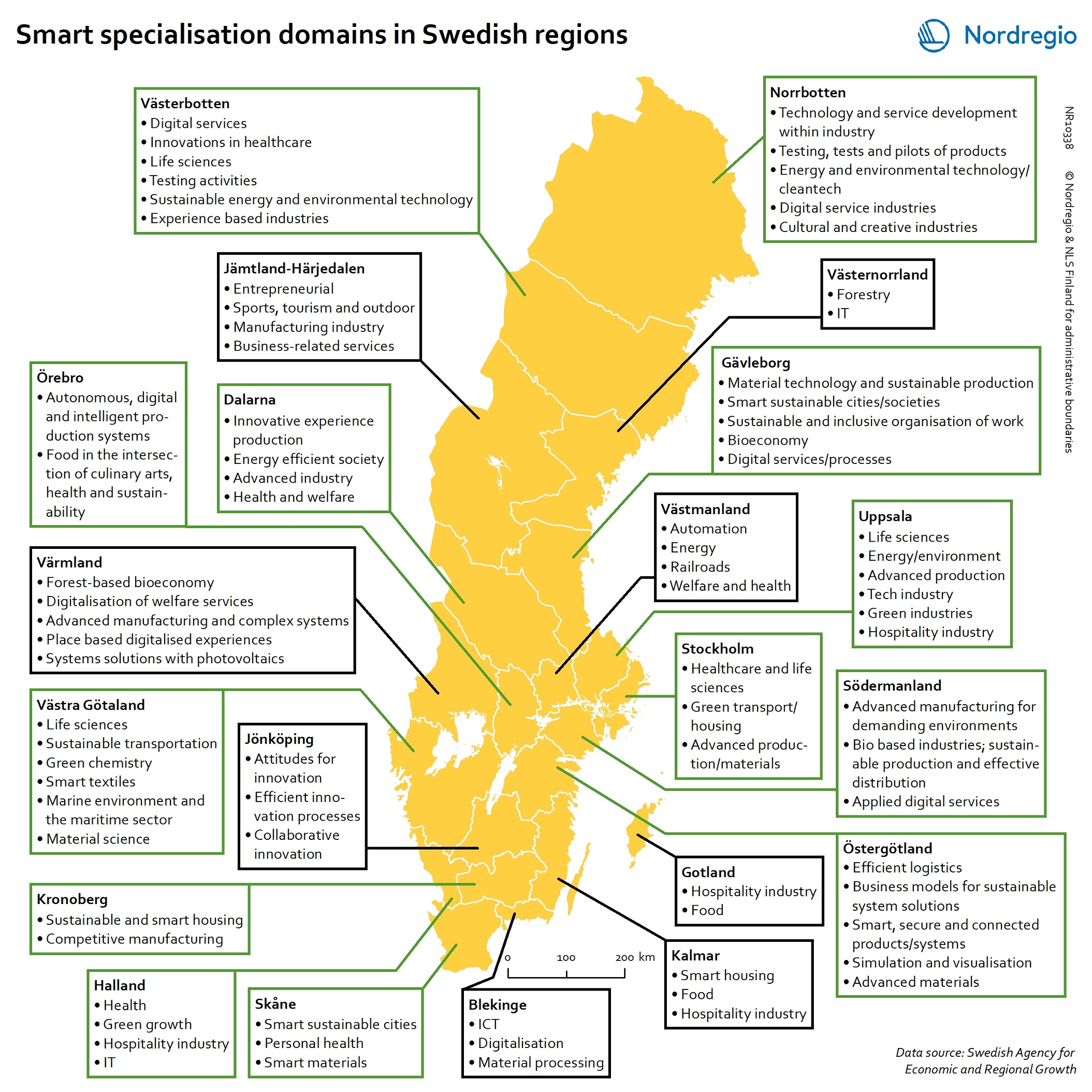
This map gives an overview of the S3 focus areas in the Swedish regions in 2019. The major S3 domains in Sweden shown in the map provide a good overview of the key specialisation areas in Sweden. It is possible, for example, to check which Swedish regions have “green”, “sustainable”, “environment” at their smart specialisation domains (marked in green in their respective infoboxes for the domains in the figure). The information illustrated in the map can assist Swedish regions when they are considering opportunities for S3 synergy and co-operation with each other. In Sweden, the Swedish Agency for Economic and Regional Growth (Tillväxtverket) is a central actor in assisting regions in their work with smart specialisation. Tillväxtverket promotes opportunities for cooperation between the Swedish regional S3 processes and provides relevant information and learning seminars related to S3. Read the digital publication here.
 2020 February
 - Economy
- Research and innovation
- Sweden
Saaʹmijânnam – Borders: 1949
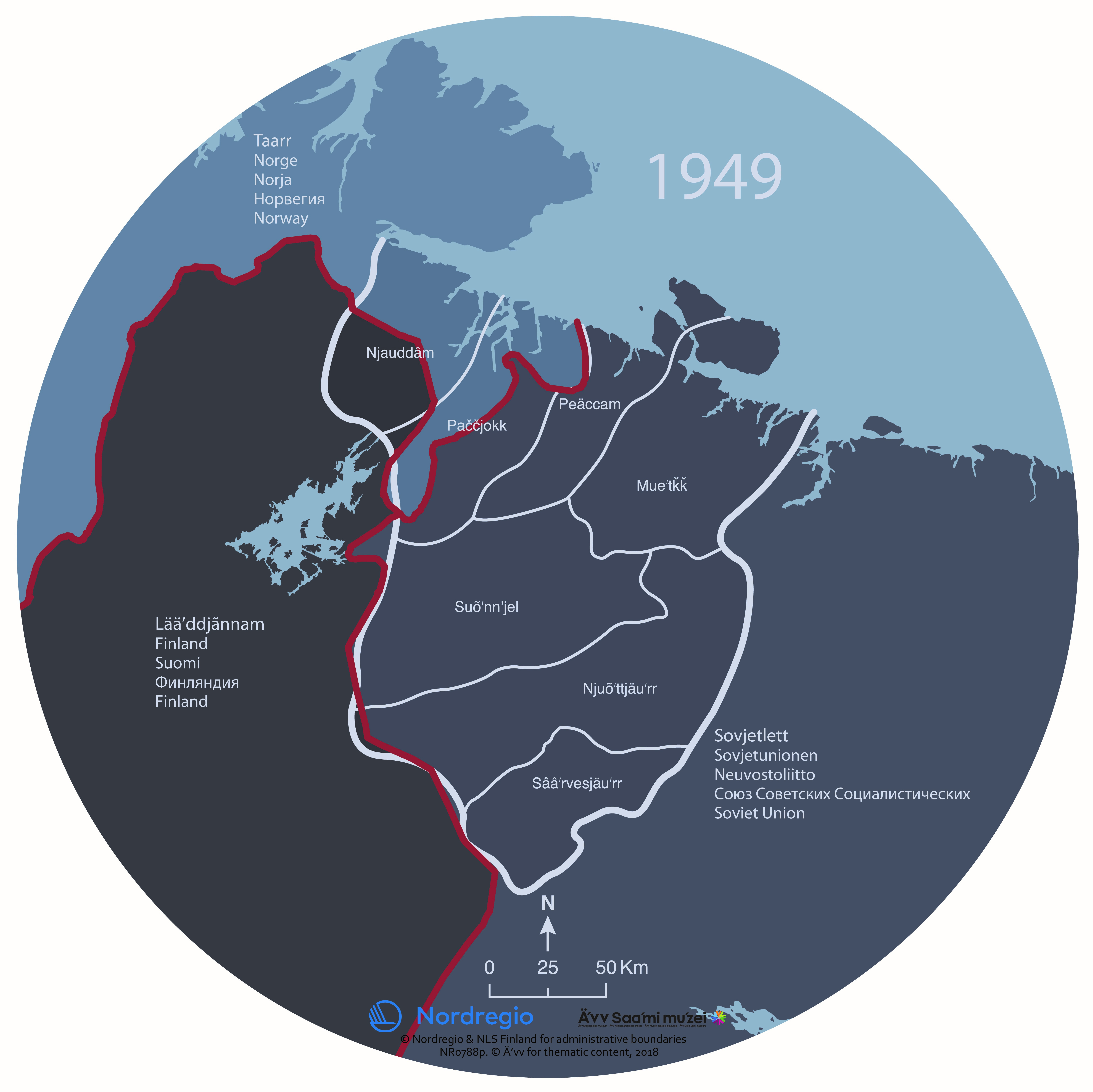
The map shows the Skolt Sámi Land and the borders of national states in 1949. The Skolt Sámi Land is the home area for the indigenous Skolt Sámi people. During the Second World War, the Skolt Sámi land was the stage of violent acts of war. After the war, borders were again redrawn. The Soviet Union took the Petsamo area from Finland. The Skolt Sámi of Petsamo were given new settlement areas in north eastern Finland. In Norway and the Soviet Union, the Skolt Sámi remained an invisible minority. In all three countries, there was very little space for the Sámi. It took decades before the human rights of the Sámi received any attention. The map was produced for the exhibition Saaʹmijânnam – The Skolt Sámi Land in Äʹvv Skolt Sámi museum in Neiden, Norway. The map is the result of a collaboration between Äʹvv Skolt Sámi museum (responsible for the reconstruction of the Skolt Sámi areas and the exhibition), Yngvar Julin (concept of maps and exhibition architect), Nordregio (base maps) and Rethink. and illustrator Ruth Thomlevold (graphic design). Back to the main project page.
- 2018 January
- Administrative and functional divisions
- Arctic
Saaʹmijânnam – Borders: 1920
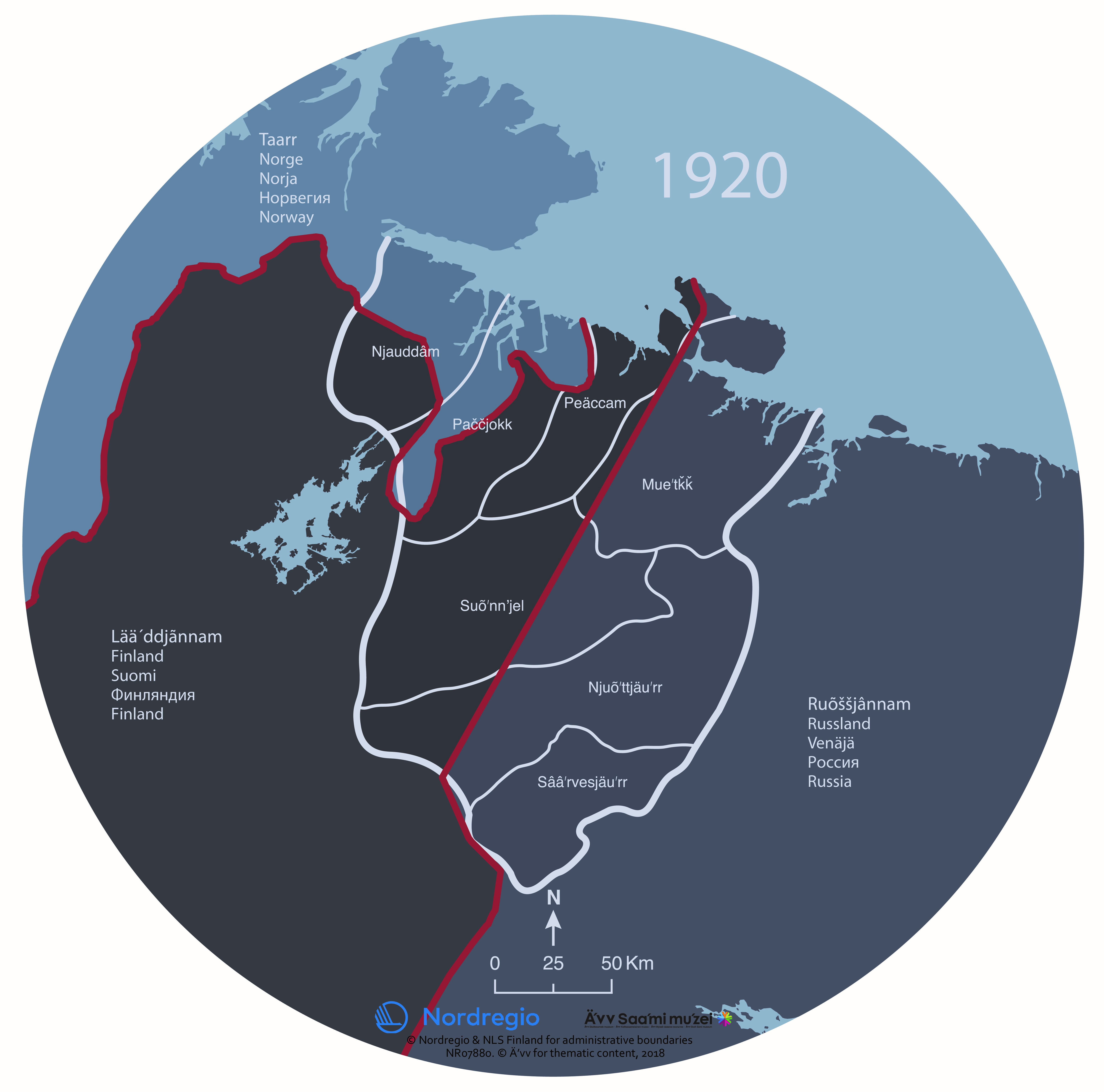
The map shows the Skolt Sámi Land and the borders of national states in 1920. The Skolt Sámi Land is the home area for the indigenous Skolt Sámi people. The borders through the Skolt Sámi Land were redrawn after the First World War. Newly independent Finland obtained the Petsamo area and thereby access to the Arctic Ocean. The Skolt Sámi living in that area became citizens of Finland instead of Russia. In Norway, the Skolt Sámi suffered from Norwegianization. On the Russian side, the Skolt Sámi were persecuted due to Stalin’s minority group policies. It became difficult to follow seasonal migration routes, a typical of the Skolt Sámi way of life. The Skolt Sámi of Suenjel area were the only ones able to carry out this traditional lifestyle. The map was produced for the exhibition Saaʹmijânnam – The Skolt Sámi Land in Äʹvv Skolt Sámi museum in Neiden, Norway. The map is the result of a collaboration between Äʹvv Skolt Sámi museum (responsible for the reconstruction of the Skolt Sámi areas and the exhibition), Yngvar Julin (concept of maps and exhibition architect), Nordregio (base maps) and Rethink. and illustrator Ruth Thomlevold (graphic design). Back to the main project page.
- 2018 January
- Administrative and functional divisions
- Arctic
- Migration
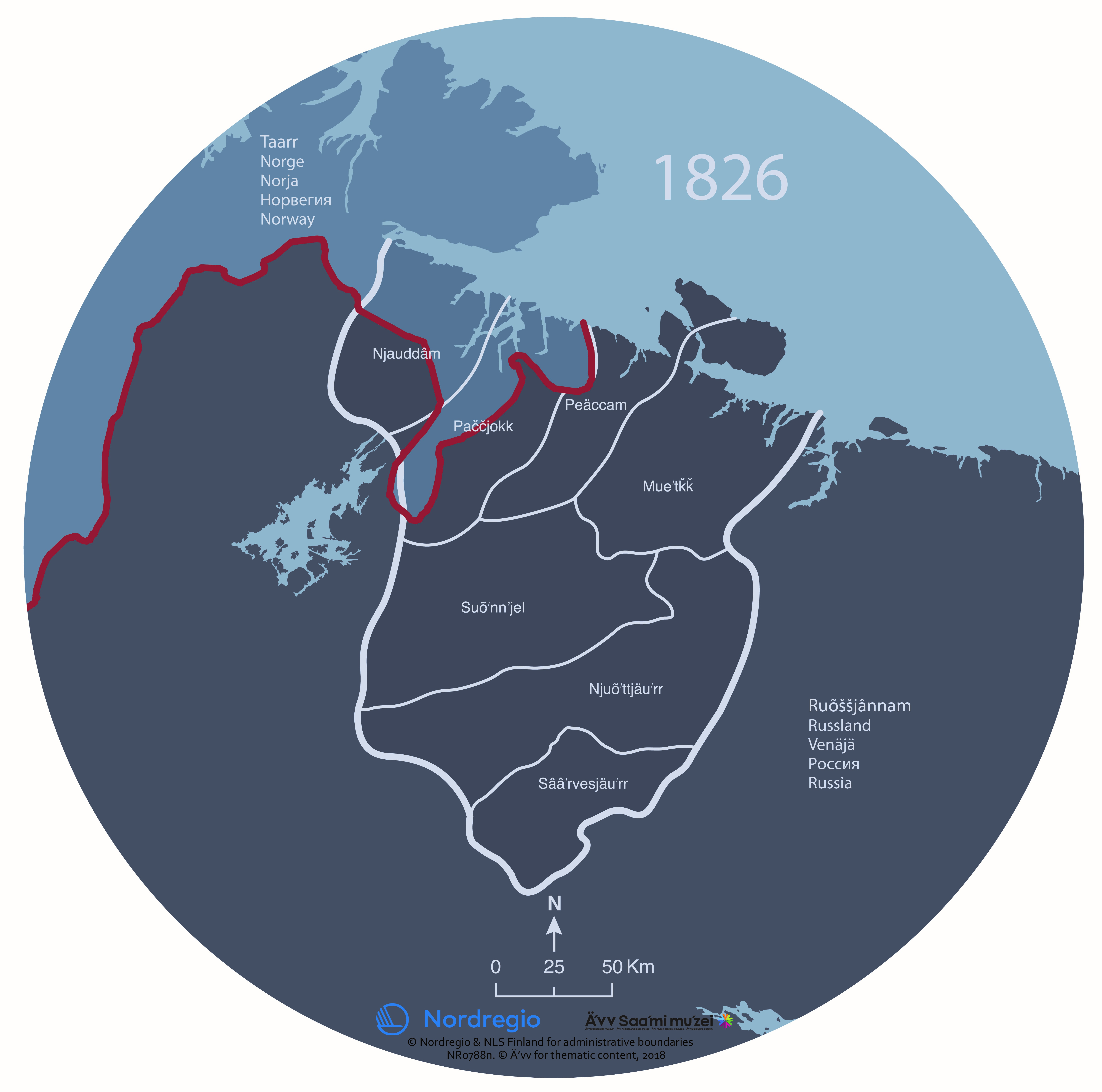
Saaʹmijânnam – Borders: 1826
The map shows how the borders of the national states in 1826 divided the Skolt Sámi Land. The Skolt Sámi Land is the home area for the indigenous Skolt Sámi people. Drawing the borders in 1826 has had a dramatic effect on the Skolt Sámi. Neiden and Pasvik areas were divided between Norway and Russia. The Skolt Sámi lost extensive parts of their living areas and their rights. They became citizens of two countries. Due to a growing number of immigrants, the competition for resources and land increased. The map was produced for the exhibition Saaʹmijânnam – The Skolt Sámi Land in Äʹvv Skolt Sámi museum in Neiden, Norway. The map is the result of a collaboration between Äʹvv Skolt Sámi museum (responsible for the reconstruction of the Skolt Sámi areas and the exhibition), Yngvar Julin (concept of maps and exhibition architect), Nordregio (base maps) and Rethink. and illustrator Ruth Thomlevold (graphic design). Back to the main project page.
- 2018 January
- Administrative and functional divisions
- Arctic
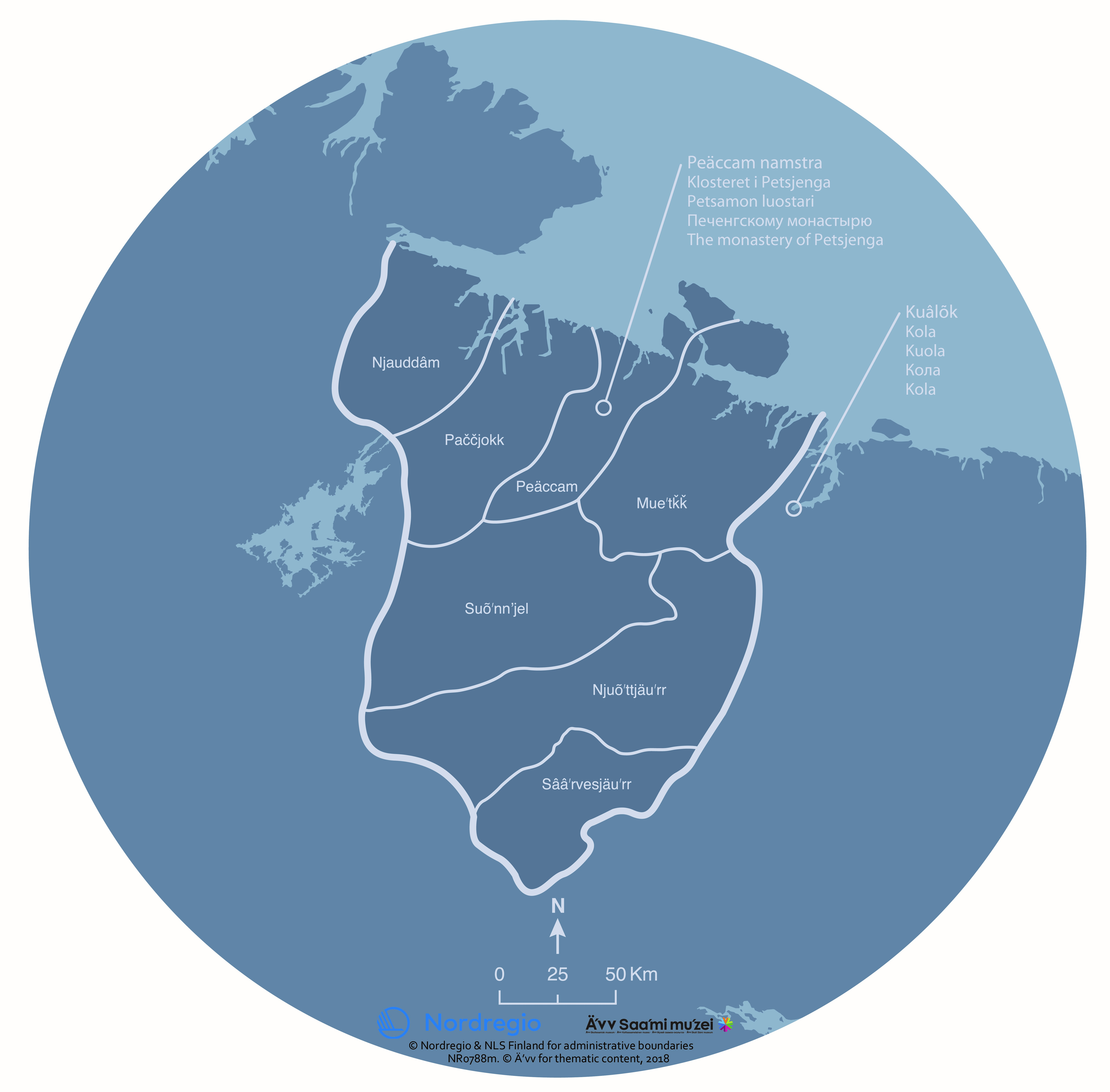
Saaʹmijânnam – the History: The monastery of Petsjenga and the fortress of Kola
The map shows the historical Skolt Sámi Land, the monastery of Petsjenga and the fortress of Kola. The Skolt Sámi Land is the home area for the indigenous Skolt Sámi people. The Russian tsar gave Skolt Sámi areas to the monastery of Petsjenga in 1556. The monastery operated a very successful business in reindeer herding, cooking salt and fishing. Petsjenga and Muetke sijdds were repressed under the monastery’s rule. The tsar had placed his officials at the fortress of Kola, in order to look after his interests in the northern areas. The map was produced for the exhibition Saaʹmijânnam – The Skolt Sámi Land in Äʹvv Skolt Sámi museum in Neiden, Norway. The map is the result of a collaboration between Äʹvv Skolt Sámi museum (responsible for the reconstruction of the Skolt Sámi areas and the exhibition), Yngvar Julin (concept of maps and exhibition architect), Nordregio (base maps) and Rethink. and illustrator Ruth Thomlevold (graphic design). Back to the main project page.
- 2018 January
- Administrative and functional divisions
- Arctic
- Others
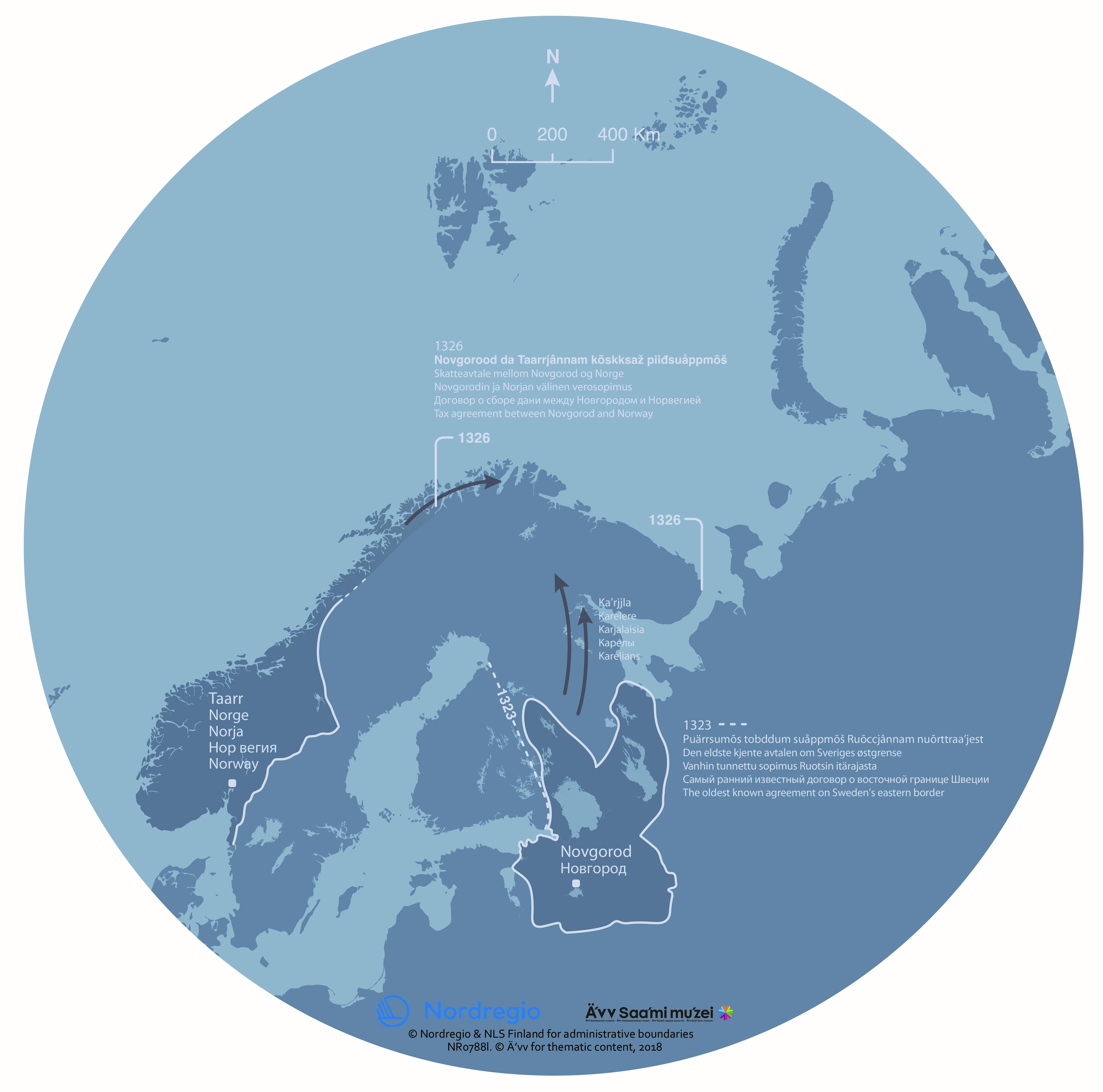
Saaʹmijânnam – the History: Taxation and borders in 14th century
The map shows some of the borders in 14th century around the Skolt Sámi Land. The Skolt Sámi Land is the home area for the indigenous Skolt Sámi people. In 1326, the treaty of Novgorod led to the Sámi being taxed twofold. The Sámi areas were under pressure from both the east and the west. Karelian and Norwegian settlements spread to the north. Karelians collected taxes from the Sámi, as they themselves were obliged to pay taxes to Novgorod. The map was produced for the exhibition Saaʹmijânnam – The Skolt Sámi Land in Äʹvv Skolt Sámi museum in Neiden, Norway. The map is the result of a collaboration between Äʹvv Skolt Sámi museum (responsible for the reconstruction of the Skolt Sámi areas and the exhibition), Yngvar Julin (concept of maps and exhibition architect), Nordregio (base maps) and Rethink. and illustrator Ruth Thomlevold (graphic design). Back to the main project page.
- 2018 January
- Administrative and functional divisions
- Arctic

Saaʹmijânnam – the History: Assumed distribution of ethnic groups around year 500
The map shows the assumed distribution of ethnic groups in Northern Europe around year 500. The map was produced for the exhibition Saaʹmijânnam – The Skolt Sámi Land in Äʹvv Skolt Sámi museum in Neiden, Norway. The map is the result of a collaboration between Äʹvv Skolt Sámi museum (responsible for the reconstruction of the areas and the exhibition), Yngvar Julin (concept of maps and exhibition architect), Nordregio (base maps), Martin Skulstad, Rethink. and Ruth Thomlevold (graphic design) and Christian Carpelan (reconstruction of the areas). Back to the main project page.
- 2018 January
- Administrative and functional divisions
- Arctic
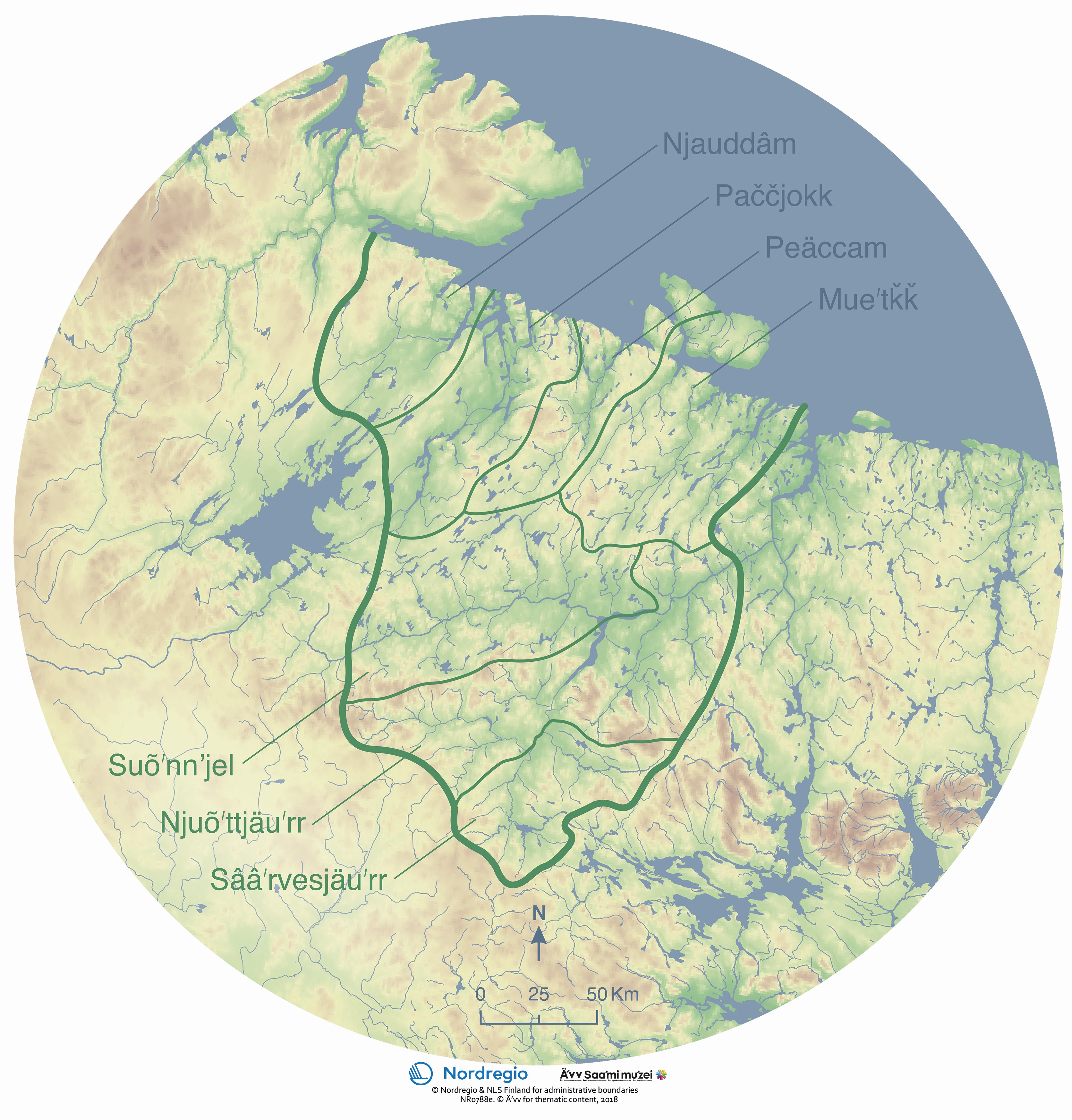
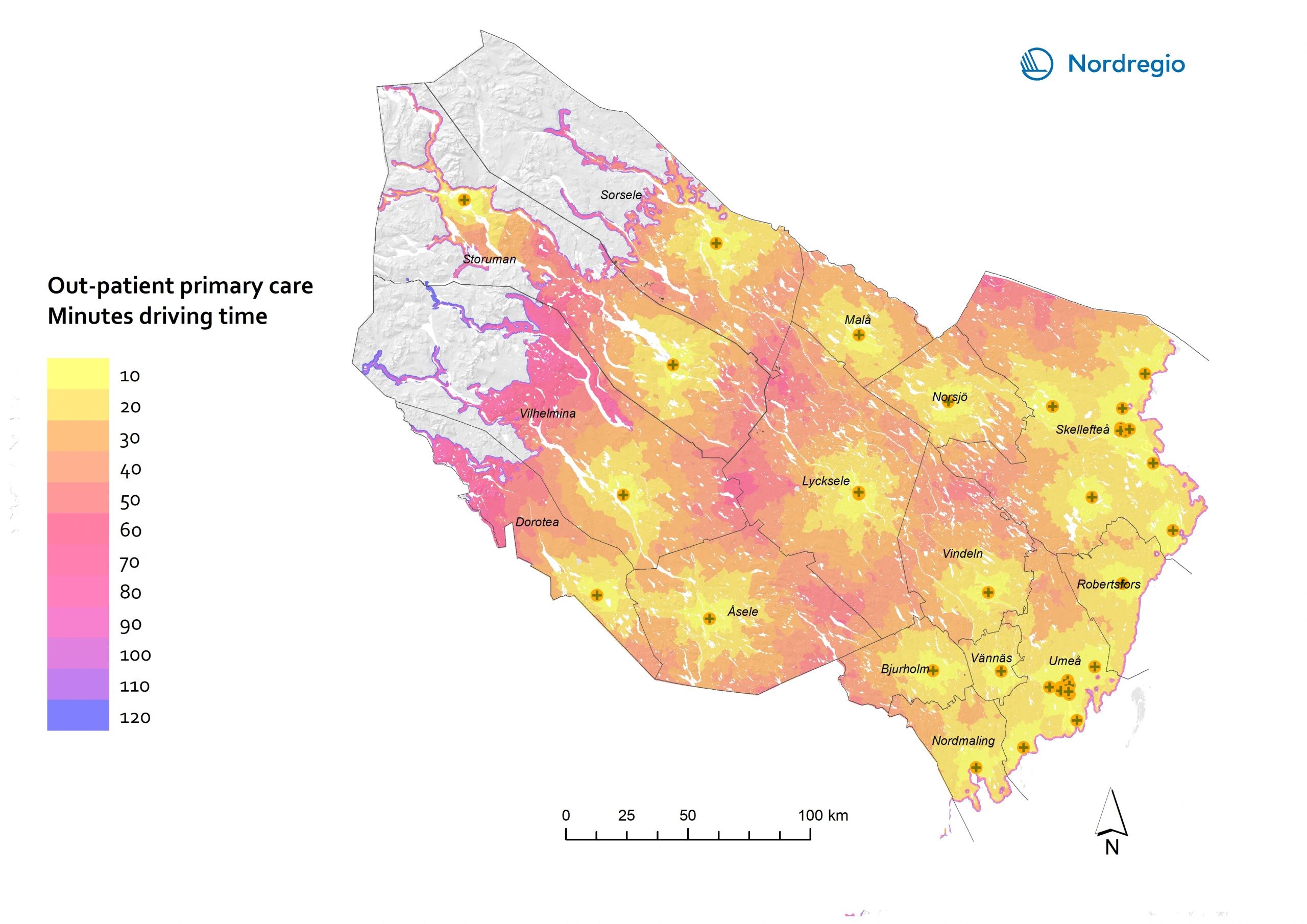
Saaʹmijânnam – the Community: Location of the Skolt Sámi sijdds with water bodies and elevation
The map shows the location of the seven Skolt Sámi sijjds. The word sijdd refers both to a geographic area and to the people who use it. The Skolt Sámi are an indigenous people with a unique culture and history. In the past, the Skolt Sámi knew exactly which areas belonged to their sijdd. If necessary, the borders of the sijdd could be redrawn by oral agreements. There were strong social ties between the Skolt Sámi areas. Marriages across sijdds were common. In some places, this sijdd system continued until World War II. In the past, the Skolt Sámi moved between several dwelling sites throughout the year. During winter, all the families of the sijdd moved to a common winter settlement. The Skolt Sámi lived on fishing, hunting and gathering. They also kept some reindeer and sheep. The resources of the sijdd were considered collective property, however movables and buildings were owned by individuals. This map shows the water bodies (lakes and rivers) according to their historical extent and location, before they were dammed up or given new courses during the 20th century. The map was produced for the exhibition Saaʹmijânnam – The Skolt Sámi Land in Äʹvv Skolt Sámi museum in Neiden, Norway. The map is the result of a collaboration between Äʹvv Skolt Sámi museum (responsible for the reconstruction of the Skolt Sámi areas and the exhibition), Yngvar Julin (concept of maps and exhibition architect), Nordregio (base maps) and Rethink. and illustrator Ruth Thomlevold (graphic design). Back to the main project page.
- 2018 January
- Administrative and functional divisions
- Arctic

Saaʹmijânnam – the Community: Location of the Skolt Sámi sijdds
The map shows the location of the seven Skolt Sámi sijjds. The word sijdd refers both to a geographic area and to the people who use it. The Skolt Sámi are an indigenous people with a unique culture and history. In the past, the Skolt Sámi knew exactly which areas belonged to their sijdd. If necessary, the borders of the sijdd could be redrawn by oral agreements. There were strong social ties between the Skolt Sámi areas. Marriages across sijdds were common. In some places, this sijdd system continued until World War II. The map was produced for the exhibition Saaʹmijânnam – The Skolt Sámi Land in Äʹvv Skolt Sámi museum in Neiden, Norway. The map is the result of a collaboration between Äʹvv Skolt Sámi museum (responsible for the reconstruction of the Skolt Sámi areas and the exhibition), Yngvar Julin (concept of maps and exhibition architect), Nordregio (base maps) and Rethink. and illustrator Ruth Thomlevold (graphic design). Back to the main project page.
- 2018 January
- Administrative and functional divisions
- Arctic

Saaʹmijânnam – the Community: Location of the Skolt Sámi Land
The map shows the location of the Skolt Sámi Land. The Skolt Sámi Land is the home area for the indigenous Skolt Sámi people. The Skolt Sámi are an indigenous people with a unique culture and history. Starting in 1826, various state borders were drawn through the Skolt Sámi homeland. Today, at least a thousand people can claim Skolt Sámi ancestry. Most of them are citizens of Norway, Finland and Russia. The Skolt Sámi Land is located in an area which today is divided between Norway, Finland and Russia. The map was produced for the exhibition Saaʹmijânnam – The Skolt Sámi Land in Äʹvv Skolt Sámi museum in Neiden, Norway. The map is the result of a collaboration between Äʹvv Skolt Sámi museum (responsible for the reconstruction of the Skolt Sámi areas and the exhibition), Yngvar Julin (concept of maps and exhibition architect), Nordregio (base maps) and Rethink. and illustrator Ruth Thomlevold (graphic design). Back to the main page.
- 2018 January
- Administrative and functional divisions
- Arctic
