Nordregio is an international research institute established by the Nordic Council of Ministers

Head of GIS department

Julien Grunfelder

Julien is no longer working at Nordregio. For contact or more information please contact nordregio@nordregio.org

Academic qualifications
Ph.D. Territorial and Urban Studies, University of Copenhagen, 2009-2012
M.Sc. EUROSTUDies (EUROpean Studies for Territorial and Urban Studies), Institute of Planning, Lille 2007-2008
M.Sc. Spatial Planning, Royal Institute of Technology, Stockholm 2005-2007

Languages
French
English
Danish

Prior positions
Traffic planner & GIS specialist, Danish Transport Authority, 2012-2013
GIS-course assistant, University of Copenhagen, 2011-2012
Visiting researcher, Transport Studies Unit, University of Oxford, 2010

Spatial Story

An unmappable territory

Exploring new territories is something I really enjoy. From a side-street of a grand boulevard in an urban context to a hiking trail in a mountainous area, I find some pleasure getting to know that such places actually exist and how they are characterized.

One object I always have with me is a map. Apart from being a great product of design when well-made, a map provides me some kind of security. In case my sense of orientation fails me, I can always rely on a map to find out where I am and how I can reach my destination by searching the path, the road or the subway station that will bring me to my desired destination. Those paths, roads and subway stations are relatively stable elements on the map; in other words, their locations are not changing overnight.

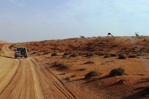
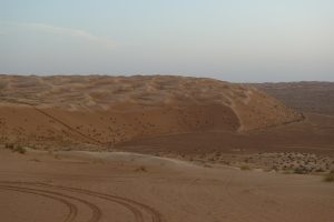
Earlier in 2013, for the first time, I experienced a territory where a map was not exactly something that would help me navigate. That situation gave me a feeling of excitement mixed with some vulnerability. This experience took place in the Wahiba Sands, a striking region of desert in Oman.

The fact that the roads, or rather the paths, as well as the dunes shift constantly does not make it easy for a newly arrived tourist to drive alone. Having a map does not necessarily help much. This territory has hardly any objects that remain geographically stable that could be great source of information to put on a map.

The most precious help was the knowledge of Nasser, a local who knew the Wahiba Sands. He gently opened the road to show where to drive and also where not to drive since a newly off-road driver can easily get stuck in a desert due to the topography of the Sands. Asking Nasser how he finds his way, the answer is: experience. It is possible for him to navigate in the dunes thanks to several trips across this fantastic landscape where he learned about the dynamics of the paths. Knowledge that is relatively hard to put on a map. Knowledge that would require frequent updates for the production of an accurate map. Anyhow, I believe exploring the desert might actually be more exciting with this feeling of vulnerability due to the absence of detailed maps. It also gives a good excuse to engage with the helpful locals.

Related Maps
How to prepare for Home Alone Christmas 2020? Travel time by train from Copenhagen or Malmö Local labour market areas in the Greater Copenhagen Region 2018 Mobility changes due to COVID-19 Change in household disposable income 2011–2017 Household disposable income – gross regional product ratio 2016 Household disposable income 2017 Change in Gini coefficient 2011-2017 Regional innovation scoreboard 2019 Gini coefficient 2017 Urban-rural typology of the Nordic regions 2020 Nordregio’s Regional Potential Index 2019 Gross regional product per capita in European regions 2017 Cosy Nordic Christmas 2019 Nordic Midsummer analysis Nordic cross-border co-operation committees 2018 Cluster analysis of Christmas 2018 Old-age dependency ratio 2030 Next Generation Access coverage 2016 FDI inflows value and FDI intensity 2003-2016 Role of international migration for population change 2011-2016 International net migration rate 2011-2016 Regional Potential Index 2017 Greenfield investment 2003-2016 Cluster analysis of employment 2015 Change in Foreign Born 1995-2015 Old-age dependency ratio 2007-2017 change Population size 2016 and 2011-2016 change in urban settlements Population size 2016 and 2011-2016 change in municipalities Population forecast 2030 Urban-rural typology of Nordic regions Last Christmas Index 2017 Nordic NIAS Council Migrants to Workers – Case study municipalities Regional Potential Index 2015 – Labour Force Potential Regional Potential Index 2015 – Economic Potential Green growth focus areas in the surveyed Nordic regions Regional Potential Index 2015 – Demographic Potential BSR-RPI 2015 – Labour Force Potential BSR-RPI 2015 – Economic Potential BSR-RPI 2015 – Demographic Potential BSR-RPI 2015 Nordic Green Growth Youth population 2016 Female ratio 2015 Employment rate among females and males in 2014 Net migration 2008-2014 Intercontinental routes from the Nordic Region 2016 Housing tenure ratio 2014 Municipal population size in 2015 and change 2005-2015 Regional Potential Index 2015 Functional urban areas 2016 Old age dependency 2015 Interreg V-B Northern Periphery and Arctic Region Programme Interreg V-B North Sea Region Programme Interreg V-B Baltic Sea Region Programme Cross-Border Programmes in the Baltic Sea Region